
welcome to this module of disaster restoration and reconstruction management you will have to explore the disaster in Rwanda and beyond worldwide , you will also have to know the areas in Rwanda prone to disaster as it is the calamities to cause even the loss of lives of people (disaster) and try to differentiate the disaster from hazards .
beside that you will be able to undergo studies about disaster community which means the participation of the local population to the mitigation , preparedness ,response and recovery from the disaster through education and behavior change.
dear students the involvement of different stakeholders are necessary to humanitarian action aid from the NGO ,government etc...
Thank you
Unit I: Overview of Disaster Management
Terminology
Disaster:
-Is a natural or human-caused event which causes intensive negative impacts on people, goods, services and/or the environment, exceeding the affected community’s capability to respond
-is a sudden, calamitous event that seriously disrupts the functioning of a community or society and causes human, material, and economic or environmental losses that exceed the community’s or society’s ability to cope using its own resources.
The purpose of this course is to give students a wider understanding of principles of water resources planning and management The main objectives and contents of this course are based on understanding of water resource management approach, discussion on planning process and implementation of water resources projects, design and protection of watersheds as natural systems that benefit both human beings and the environment. Basic theories and design skills of rainwater harvesting systems and integrated water resources management (IWRM).
At the end of this course students will be able to explain changes that occur in watersheds—both natural and human-induced changes, to understand the basic theory, designing skills of the rainwater harvesting system; and to understand principles of Integrated Water Resources Management.
The
course aims to provide students with competence in analyzing and designing special structures. It covers the analysis and design of curved beams, plates, plate girder, box girder, box culverts, composites structures and silos.
The module introduces students to port and harbor engineering as part of coastal engineering. It equips students with knowledge and skills in engineering applications at ports and harbors. It will develop the ability to analyze relevant topics pertaining to port and harbor engineering. It provides theoretical and practical modes for students to utilize in port and harbor engineering applications.
The course aim to provide the basic understanding of water turbines. This module covers further the design equations and illustrative examples of such hydraulic structures. It gives also an explicit understanding of hydropower generation and energy analysis. Having successfully completed this module, students should apply all procedures required for a complete feasibility study of a mini-hydropower project: Technical feasibility (or design), financial feasibility (or cost implications of the project), social feasibility and EIA of the project).
Greetings Dear Participants
This is to welcome you in Land Use Planning II
The aims of this module is to provide the students the knowledge on the understanding of Spatial data Information gathering from different sources, Spatial Analysis and layout & physical Plan preparation especially in urban set up.
Brief Description
This module is a continuation of land use planning I . it seeks to deepen student understanding of spatial data and spatial analysis in land use planning especially in urban set up. It will give students a basis to apply the skills and techniques learned to logistical and practical problems of cities and regions, including land use allocation and suitability assessment, landscape assessment and the impacts of urban growth. As a foundation for the applied issues to be addressed during the course, students will be familiarized with some basic planning concepts concerning land use, land development, infrastructural and landscape planning. Students are also expected to learn how to prioritize needs and work efficiently in a professional context, problem solving and communication skills through in-class discussions, on-line forum discussions and presentations.
This course introduces the concept and foundation of laws, then focuses on specific legal provisions relevant to surveying and geomatics engineering. By the end of the module learner should be able to:
- Familiarize with relevant legal terminologies and categorizations of laws.
- Explore major legal systems of the world and Rwandan legal system.
- Adhere to contract laws, environmental law, planning provisions and land law of Rwanda.
- Familiarize with provisions of law and professional ethics relating to surveying and Geomatics engineering.
The course expands the scope of cadastre and land management. It is closely related to GIS database and spacial data infrastructure. Legal issues regarding cadastre data sharing will also seen. Case study will also be presented to make learners have a clear understanding of the subject.
This course covers Building Information Modeling (BIM), including its use and application for small and large-scale building construction projects. Students will learn terminology associated with buildings, the theory and evolution of BIM, and how to develop BIM models using Autodesk Revit. This course will also cover selected topics on how BIM is used to help prepare or feed into key project items, such as cost estimation, structural, MEP (Mechanical, Electrical and Plumbing) architectural renderings, interfererence checking, and modeling of energy consumption.
Brief description of aims
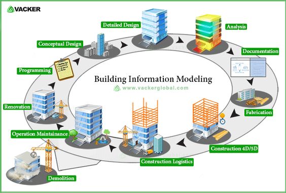
This course covers Building Information Modeling (BIM), including its use and application for small and large-scale building construction projects. Students will learn terminology associated with buildings, the theory and evolution of BIM, and how to develop BIM models using Autodesk Revit.
This course will also cover selected topics on how BIM is used to help prepare or feed into key project items, such as cost estimation, structural, MEP (Mechanical, Electrical and Plumbing) architectural renderings, interfererence checking, and modeling of energy consumption.
The course aims at presenting the history of bridge engineering, different types of Bridges and materials of construction. It provides a body of knowledge and skills on design of bridges structures by introducing the fundamental concepts, principles and application for analysis and design of superstructure and substructure of Bridges. It also introduces practices for maintenance, inspection and aesthetics. Loading analysis and Design for different types of RC bridges, according to their materials and structures are discussed.
The course aims to provide the advanced analysis and design of special structures, assessment and monitoring of structures. It covers analysis and design of curved beams. The course will cover the design and analysis of plates. Design of box beams, Analysis and design of Box culverts. Analysis and design of composites structures, Analysis and Design of Silos.
The course intends to provide the students with an introduction to the atmospheric processes which govern the earth’s climate and which control the surface water fluxes of the hydrological cycle, with a synoptic overview of the earth’s energy budget as a major driver for planetary-scale motion and atmospheric instabilities. This includes the issue of climate change, the possible reasons for climate change, and the natural variability of climate. Finally, it intends also to explain the synoptic and local processes that drive rainfall generation at different spatial and temporal scales and introduce global and regional climate models and their use in weather forecasts and climate change projections. It will finally look at how Human activities have effects on climate change and how they are changing rainfall patterns worldwide.